
Father Pitt found time for a few last pictures of Gateway Center just hours before the station closed forever. In two years or so, we’ll have a big new station, but old Pa Pitt will still secretly miss the little old one just a bit.


Father Pitt found time for a few last pictures of Gateway Center just hours before the station closed forever. In two years or so, we’ll have a big new station, but old Pa Pitt will still secretly miss the little old one just a bit.
“Pittsburgh Recollections,” installed when the Gateway Center station opened in the middle 1980s, takes us from canoes down the Allegheny to these marvelous modern mainframe computers with their gigantic reel-to-reel tape drives full of data, by way of the French and Indian War, Conestoga wagons, the riverboat era, a banjo that doubtless accompanied songs by Stephen Foster, and the age of steel. The Port Authority is raising money to have the mural restored and reinstalled at the new Gateway Center station. (UPDATE: The mural has been restored and reinstalled at Gateway station.)


A kind reader who signs himself “Matt” had an excellent suggestion:
Any interest in photographing or featuring the old Gateway Center Station one last time before it closes forever this weekend?

It was never a beautiful or impressive space, but of our trio of odd underground stations, Gateway Center was the oddest. It will soon be replaced by a gleaming new station that will doubtless be more convenient and more beautiful. But old Pa Pitt confesses that he was always sneakily proud of the old Gateway Center station when he brought out-of-town visitors downtown. They might come from cities with more expensive or more comprehensive subway systems, but few subway stations are as just plain weird as Gateway Center was. Notice, for example, the low-level platform, now closed off by a rail, that was built to accommodate the old PCC cars when they still ran the Overbrook route—a feature shared by all three of the underground stations downtown.

The weirdest aspect of Gateway Center, of course, was the loop. Visitors riding the subway for the first time were always alarmed to see the station they wanted flashing by on their left, as though the car had somehow just missed it. Then came the long squealy loop that threw everybody to the right-hand side of the car, and finally the car re-emerged into the station, this time with the platform on the right side.

We’ll see more pictures of the old Gateway Center station shortly. Meanwhile, the subway ends at Wood Street until further notice, except for the next few weekends, when it ends at First Avenue.
![]()
Click on the image for a PDF copy.
Update: The map above is Father Pitt’s latest map of Pittsburgh rapid transit. This article is kept here for historical reasons, but the map below is out of date.
—
The new Transit Development Plan has changed [updated from “will change”] the names of the streetcar lines from route numbers to colors, which is so obviously sensible that Father Pitt wonders why no one thought of it before.
Here is Father Pitt’s revised map of Pittsburgh rapid transit, which takes the changes into account:

Once again, old Pa Pitt attempts to explain what he means by “rapid transit.” For Father Pitt, “rapid transit” is any form of mass transit that runs on its own dedicated track: in other words, what the Port Authority calls “fixed-guideway systems,” a lovely slice of terminology that would warm the cockles of a bureaucrat’s heart if there were any cockles in there. That includes trolleys or streetcars, the subway (which is just the streetcars running underground), and the inclines, all of which run on rails. It also includes the busways, which are completely grade-separated tracks that run like metro lines.
The HOV lanes on the Parkway North are included as “rapid bus” routes on the Port Authority’s new system map (available here in PDF format), but not here; see an explanation at the earlier version of this map.
So far we have what is, which old Pa Pitt is delighted to find is at least halfway to what ought to be. For the next step, Fathr Pitt will soon provide another map—one that shows how the Pittsburgh Metro ought to work.
Can you imagine Pittsburgh with a comprehensive metro system to rival Montreal’s or Washington’s? How much do you think it would cost? How much do you think the contract would be worth to the lucky bidder?
Father Pitt expects to win that bid, because he will undercut any competitors’ bids so severely that they will be forced to admit defeat.
Father Pitt will give you a complete metro system for nothing. Free, gratis, without charge.
How can he afford to do that? Is he wealthy beyond the dreams of avarice?
Well, of course he is, but that is not strictly relevant. Old Pa Pitt can give you a metro system for nothing because only he knows the secret. You can have a metro that would be the envy of any comparable city if you will but open your eyes and see that you already have it.
Old Pa Pitt is a busy man these days, what with dusting two and a half centuries’ worth of accumulated detritus just in case Chancellor Merkel should decide to take a white glove to his shelves. This is his excuse for not yet having released his plan for rapid-transit development in Pittsburgh, which he had nearly finished months ago. This was the map he had prepared:

One of the main planks in his rapid-transit platform was to make the rail system easier for novice riders by replacing the arcane route numbers with colored lines, as most rail-transit systems in this country have done. He had prepared a map that showed Routes 42S and 42C as the Red Line, Routes 47L and 47S as the Blue Line, and Route 52 as the Yellow Line.
You may imagine his considerable amusement, then, when the Port Authority released a Transit Development Plan a little while ago, in which—among other changes—the rail routes are now designated by colors rather than by numbers. Routes 42S and 42C will be known as the Red Line, Routes 47L and 47S as the Blue Line, and Route 52 as the Brown Line.
The coincidence in color choices is less extraordinary than you might think. Until a few years ago, although the lines had been designated by route numbers, the system maps had always shown Routes 42 as red lines and Routes 47 as blue lines. Why brown, of all colors, should represent the Allentown Trolley is a question Father Pitt prefers not to waste too much time pondering. President Zuma is reputed to be unusually fastidious, and there is scrubbing to be done.
But the Port Authority’s plan only goes halfway. Pittsburgh’s busways are the other half of the system.
Other cities like Boston and Cleveland have integrated “bus rapid transit” lines into their rapid-transit system maps. Yet those are halfhearted affairs, mixing with street traffic and subject to many of the inconveniences of ordinary buses.
Pittsburgh, almost alone in North America, has built real metro lines for buses. There are no at-grade intersections at all; the buses have their own track from one end of the busway to the other. These high-speed transit lines deserve to be recognized as part of the Pittsburgh Metro. And marketing them that way would make them both easier to use and more attractive.
In a few days, Father Pitt will release two more maps. One will be an updated map of the rapid-transit system as the Port Authority sees it (update: now posted here). The other will be an updated version of the ideal Pittsburgh Metro. Watch this space carefully.

A big hole in Stanwix Street marks where the new Gateway Center subway station is under construction below. When the new subway line to the North Side opens, this larger station will replace the old Gateway Center subway station, with its squealing underground loop and single platform.

A two-car 47S train rolls into the Steel Plaza subway station in early rush hour.

A 47L train heads across the Panhandle Bridge as it sets out on its long journey to the edge of the earth, which in this case is Library, at the southern border of Allegheny County. In rush hour, all routes except 52 (the Allentown Trolley) run two-car trains like this one, made up in this case of two CAF cars. The rear car acts as a trailer; it has no driver, and its doors open only at high-level platforms with fare booths, not at street-level stops.
The Panhandle Bridge was originally a railroad bridge; in the 1980s the streetcars from the South Hills were diverted over it (they used to come in by the Smithfield Street Bridge) when the new subway opened. (Part of the subway reused the old railroad tunnel that had taken trains from the Panhandle Bridge to Penn Station.) Since the cars come out of the Mount Washington tunnel right at the end of the Smithfield Street Bridge, diverting them to the next bridge over required an extraordinarily sharp curve at Station Square. But sharp curves are just one of the challenges a trolley has to pass before it’s good enough for Pittsburgh.

It may be a bit perverse to call it a subway station when it’s clearly an elevated station, but this is the section of combined streetcar lines that Pittsburghers generally call the subway. Most of it is indeed underground; First Avenue is the only elevated station downtown. Above, an inbound train arrives on its way into the subway tunnel; below, an outbound train picks up passengers.

Since we were speaking of Pittsburgh transit, it’s time for some trolley geekery: here is the Pittsburgh LRV as advertised on the site of the company that makes it, Construcciones y Auxiliar de Ferrocarriles.
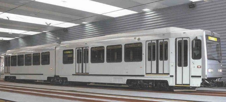
You can read the proudly technical description of the cars’ features and details, although oddly the “doors per side” spec leaves out the extra street-level door (what we might call the “Pittsburgh door”) at the front. The same Spanish company made the cars for Sacramento’s light-rail system, as well as many European tram networks.
These are the newer cars on the Pittsburgh rails, the 4300 series. The older cars, the 4200 series, came from Siemens Duewag in Duesseldorf. They have almost all been rebuilt to the same standards as the newer cars, so that they’re nearly indistinguishable from the CAF cars. Aside from the car numbers, the easiest way to distinguish the cars is from the front or back. The Siemens cars have a pair of headlights side by side in the center; the CAF cars have headlights toward the sides, like a conventional automobile or bus. The Siemens cars also have a “Cyclops eye,” a separate high-beam light mounted on top of the car; the CAF cars have the high beam incorporated into the body of the car above the windshield.
The Port Authority bought 55 Siemens cars to run on the rebuilt Route 42 line in the 1980s; the other lines, too rickety for the heavy new trolleys, still ran PCC cars. In 2004, the Route 47 line through Overbrook reopened after extensive reconstruction, and the Port Authority bought 28 cars from CAF. In total, that makes 83 cars, but old Pa Pitt has had some trouble figuring out how many are actually in service. Some Siemens cars may not have been rebuilt, and may be languishing somewhere in the enormous car barn at South Hills Village. At any rate, the number in service is fairly large, since the cars are run in pairs during rush hour, averaging less then five minutes apart downtown.