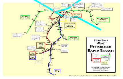
Update: Here is old Pa Pitt’s most recent map of Pittsburgh rapid transit:
Click on the image for a PDF copy.
The article below is kept here for historical reasons, but the map below is out of date.
—
Public transit, like everything else in Pittsburgh, is wonderfully confusing. We have buses, busways, streetcars or trolleys, inclines, and subways (the main one where the streetcars run downtown, as well as a subway for the streetcars in Mount Lebanon, a transit tunnel for buses and streetcars under Mount Washington, and a long tunnel on the West Busway).
For our purposes, “rapid transit” means what the Port Authority bureaucrats call “fixed-guideway systems,” meaning transit that runs on rails or on its own dedicated track. Streetcars or trolleys (the terms are interchangeable here) sometimes run on the street with the rest of the traffic, but they have their own rails. Busways are high-speed tracks for buses that work like subways, with infrequent stations rather than a stop on every corner. Inclines go from down to up or up to down.
If you prowl around the Port Authority’s Web site long enough, you can find maps of most of these things. But you can’t find a map that tells you how much fun you can have. Here’s where old Pa Pitt steps in with a map that shows you how to use rapid transit to get to some of Pittsburgh’s main attractions.
The obvious missing piece in our transit system is a rapid-transit line to Oakland, the intellectual heart of Pittsburgh. Bus service from downtown to Oakland is frequent, but many people refuse to ride buses who would ride rapid transit. There is, however, good reason to hope that the omission will be corrected soon. Meanwhile, here is a map of the otherwise excellent system we do have. Click on the image to download the map in PDF form.


Leave a Reply to Hack Pittsburgh » Fri – Transit in Pittsburgh Cancel reply