The Mexican War Streets are a dense rowhouse neighborhood, and as in most such neighborhoods, each block tended to have small businesses on the corners—especially neighborhood groceries and backstreet bars. The corner of Monterey Street and North Taylor Avenue had four such businesses, one on each corner. Only one of the storefronts is occupied as a business now, but the others retain most of the original features, and each building emphasized the corner location in its own way.
This one blunted its corner to make a corner entrance.
This one did the same, but without the expensive stone trim.
This one also has a corner entrance, but the rest of the building is rectangular, with the corner held up by a stout pole—a common arrangement in small corner storefronts.
Tasso Katselas designed this building, put up in 1965, and in old Pa Pitt’s eyes it is one of his most successful designs. It conveys its message perfectly: this is a place where the future is being made today. (We remember having heard that slogan somewhere: it might have been at the Pitt Information Sciences Department.) Yet it has enough variety, enough light and shade, and the right scale and setback to fit well with the older buildings on Bellefield Street.
Now known as the Cardello Building, this was one of several locations of the National Casket Company, a concern that, by combining the leading casket makers into one conglomerate, nearly cornered the market on death.
The lens on this old Ansco camera is a “normal” lens that sees the world about the way your eyes see it, so that acute angle is not a lens artifact. It really is an acute angle.
The building is actually a complex of connected buildings put up over the course of twenty years, from 1900 to 1920. The same architect was responsible for all of them: R. Maurice Trimble, who came from a family of contractors and fed work back to various Trimbles whenever he had a chance. (See the end of this article for the citations that mention Trimble as architect.)
We found multiple listings mentioning Trimble as architect of various parts of the National Casket Company building. Here are three of them.
Record & Guide, July 18, 1900, p. 463. “Maurice Trimble, Ferguson Buliding [sic], has made plans for a three-story brick warehouse to be erected on Chartiers street, Allegheny, for the National Casket & Coffin works. The owners are receiving bids for its construction.” Chartiers Street is now North Point Drive. By the time it was built, the warehouse had grown to four floors. The 1910 Sanborn map shows that this was the section between the five-storey section that faces Beaver Avenue and the five-storey section at the south end of the complex. Now known as the Cardello Building.
Record & Guide, December 17, 1902, p. 835. “R. M. Trimble, Ferguson Building has awarded to John H. Trimble & Bro., 2022 Chartiers avenue, Allegheny, the contract for the erection of a five story brick and stone warehouse and office building for the National Casket Company at Seventh street and Duquesne way.” This probably refers to the five-story section at the south end of the National Casket Company warehouse on Chartiers Street; the downtown address would be the offices of the company. Other listings confirm, however, that John H. Trimble & Brother were located at 2022 Chartiers Avenue, right next to the National Casket Company which is very convenient. We note Maurice Trimble’s habit of keeping the construction in the family if he could manage it.
“Casket Company to Build,” Post, August 31, 1920, p. 7. “The National Casket Company has given D. T. Riffle a contract for an addition to a building on Reedsdale street, Northside. R. M. Trimble is the architect.” This is the most recent section, filling out the building to Reedsdale (now part of Beaver Avenue).
Since Trimble was the architect of the first section of the warehouse and the most recent section, and since everything matches the one or the other in style, we can be fairly confident that he designed all the stages of construction, however many there were.
We have seen pictures of this building before, but a fine building in poor condition will disappear sooner or later without a miraculous intervention, so it is always good to seize the opportunity to harvest a few more pictures when one is in the neighborhood. (There’s a for-sale sign on the door: you could buy this building right now and make the miracle happen.) The educational wing was built in 1928; it was designed by Lawrence Wolfe, with O. M. Topp, one of the architects of the original 1911 church to which it is attached, as associate architect.1
The Charette, June, 1928: “507. Architect: Lawrence Wolfe, 119, E. Montgomery Ave., N.S., Pittsburgh, Pa. (O. M. Topp, Associate Architect). Title: School Building for Second Presbyterian Church, Wilkinsburg, Pa. Location: Franklin and Mulberry Streets, Wilkinsburg, Pa. Ready for bids July 15. Approximate size: Three stories and basement. Cubage: 200,000 cu. ft. Stone walls.” ↩︎
Some sights on one side of one block of Western Avenue, the business spine of Allegheny West. Though it has become a trendy and prosperous business district, Western Avenue still keeps its quirky combination of commercial buildings, private houses, and houses turned into commercial buildings.
This is a designated historic district, so that is a historic utility cable.
This is the only house on the street that has not been expensively restored. Much original Italianate detail is left for the next ambitious owner to savor.
Above, Lanark Street in Fineview in 1994. The houses had suffered many unsympathetic alterations, but they were inhabited. After this picture was taken, Fineview declined to probably its lowest point; several of the houses vanished. But the decline hit bottom about fifteen or twenty years ago.
It is almost impossible to take an ugly picture of the terminal at Allegheny County Airport. It was designed by Stanley Roush, the king of public works in Allegheny County. The airport engineer was G. Brooks Ross, shown here hard at work on his plans.
Pittsburgh Post-Gazette, March 28, 1929.
When it opened in 1931, the Allegheny County Municipal Airport was at least arguably the largest and most sophisticated airport in the world. When we consider that 1931 was only four years after Lindbergh’s flight, and that the site and general size of the airport had been decided on in 1928, we realize what a huge gamble this airport was: the future of air travel was unknown, and it required far-sighted faith to believe that an airport of this size would be required in years to come. (Even now a 737 can land here if it’s necessary.) It also required quite a bit of complicated financial trickery from the Republican majority on County Council and their allies, as Post-Gazette cartoonist Cy Hungerford points out.
From the Pittsburgh Post-Gazette, September 12, 1931.
Under the old county charter, County Council had two members from the majority party and one from the minority party. Everything was done behind the sputtering Democrat’s back, and he found out about it in the papers like the rest of us as the cost of the Municipal Airport went up and up. This, by the way, was one of the last great projects of the Allegheny County Republican machine, before the Democratic tide swept in with Franklin Roosevelt.
The faith was more than justified. By the end of the Second World War, air traffic had increased to such an extent that an even larger airport was needed; and County Airport had already filled its site to the practical limit. Thus Greater Pitt was built out in the western suburbs, and all the scheduled commercial flights moved there. But County Airport, much closer to downtown, remained the favorite airport for private and corporate planes. Today it is still the fifth-busiest airport in Pennsylvania, with about 160 flights a day.
And that is the almost unique combination of needs that pickled this airport in the 1930s. (We say almost unique because Cincinnati’s municipal airport of the same era has survived for the same reasons.) Greater Pitt has been rebuilt twice since it opened in 1952, because the needs of commercial air traffic keep changing. But this airport has remained exactly the right size for the traffic it handles. The striking Art Deco terminal is such a perfect period piece that it often plays The Airport in movies set in the 1930s; except for covering the inscription with a suitable city name (and carefully framing to cut out the more recent control tower), the building is ready for filming.
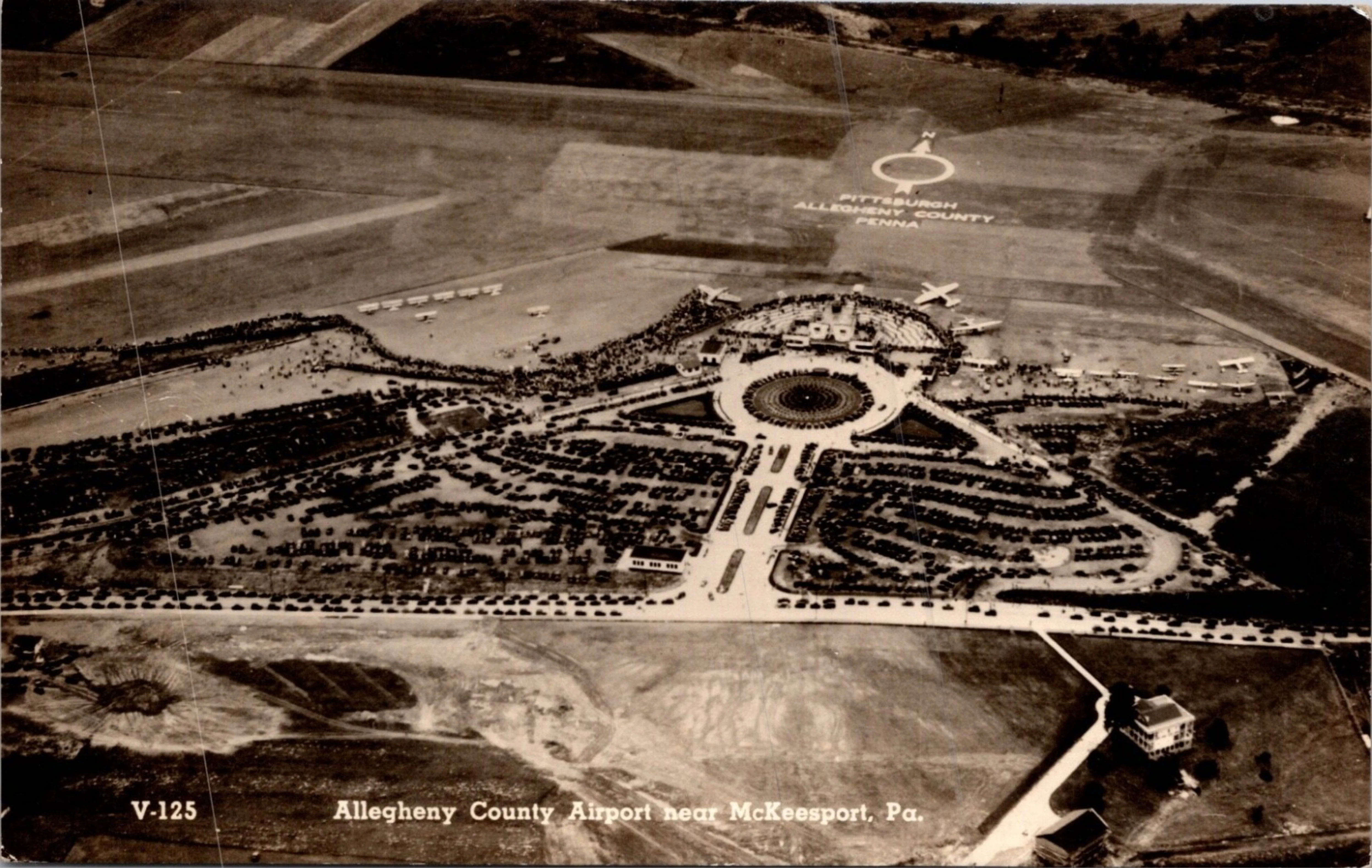
No current pictures can convey how carefully this airport was designed to make its impression from the air, but fortunately we have this 1941 postcard. Not only was the air traveler supposed to be impressed by the magnificent portal to Pittsburgh, but the design was also—in the days when all air navigation was visual—extraordinarily helpful to pilots. The broad boulevard that leads to the terminal was a fat arrow pointing due north toward the airport. The directions were immediately obvious. For pure decoration, the zigzag patterns of the terminal were echoed in a semicircle of pavement behind the building—now, alas, plain asphalt. Today, the view from above is a cluttered mess, because the airport grew more buildings and the area around it suburbanized. But when it opened in 1931, the airport was a beautiful abstract design from the air, complete with a huge identifying label in the airfield.
Now let’s step inside the terminal and wander around for a bit.
George H. Schwan was the architect of this parish house,1 built in 1906 for Christ Episcopal Church. Like the First United Presbyterian Community House next door, it somehow survived when its church was demolished for “urban renewal” in Allegheny Center.
Record & Guide, September 27, 1905, p. 629. “Architect George Schwan, 326 Fourth avenue, has prepared plans for a brick parish house to be erected on Union avenue, Allegheny, for Christ Episcopal congregation, at a cost of about $30,000.” Ultimately the building was faced with stone and probably cost a good bit more. ↩︎